
Project Stories12 min read18 October 2026
SLAM Explained: How Autonomous Robots Build Maps and Locate Themselves
Simultaneous Localization and Mapping (SLAM) enables autonomous robots to explore unfamiliar environments while building maps and estimating their own positions. This article explains how SLAM works, the sensors and algorithms involved, practical implementation with ROS 2, common challenges, and real-world applications.
By Anonymous Writer
1. Introduction
Imagine placing a mobile robot inside an unfamiliar building. It has no map, does not know its exact position, and must explore without colliding with walls or furniture.
How can it navigate safely?
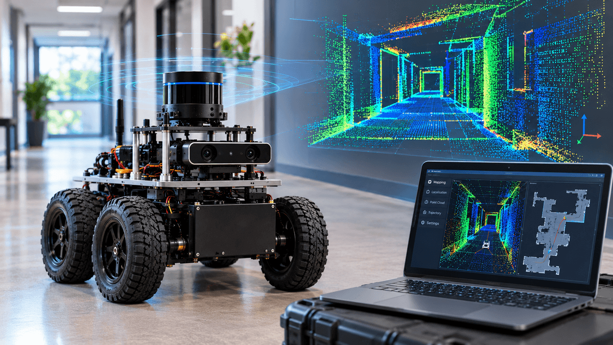
The answer is Simultaneous Localization and Mapping (SLAM). SLAM allows a robot to construct a map of an unknown environment while estimating its own position and orientation within that map.
SLAM is a foundational technology in autonomous robotics. It supports warehouse robots, autonomous vehicles, delivery robots, drones, and robotic systems used for exploration.
Unlike a robot that follows a preloaded map, a SLAM-enabled robot can gather environmental information as it moves and continuously improve its understanding of the surroundings.
2. Understanding SLAM
SLAM solves two closely connected problems.
Mapping: The robot identifies environmental features and uses sensor observations to construct a representation of its surroundings.
Localization: The robot estimates where it is located and which direction it is facing relative to the map.
These problems depend on each other. A robot needs an estimate of its position to place new observations correctly on the map. At the same time, it uses the map to improve its position estimate.
For example, when a robot observes a doorway it has encountered before, it can use that observation to determine whether its current position estimate is accurate.
This relationship makes SLAM more challenging than simply drawing a map or tracking movement independently.
3. Why SLAM Is Important in Robotics
Traditional navigation systems often depend on a map prepared in advance. However, many robots operate in environments where maps are unavailable, incomplete, or frequently changing.
SLAM helps overcome this limitation by enabling robots to build environmental knowledge during operation.
Its major benefits include:
- Autonomous exploration: Robots can enter unfamiliar spaces and begin mapping.
- Improved localization: Environmental observations help correct accumulated position errors.
- Flexible navigation: Maps support path planning and obstacle avoidance.
- Reduced dependence on external infrastructure: Many SLAM systems can operate without GPS, particularly indoors.
- Reusable environmental maps: A completed map may support later navigation, depending on the system and environmental changes.
SLAM does not automatically make a robot fully autonomous. It provides essential spatial information that other navigation and control systems use.
4. Sensors Used in SLAM
Different sensors provide different types of environmental information. The best sensor configuration depends on the robot, its operating environment, cost, and required accuracy.
LiDAR
LiDAR measures distances using laser light and produces measurements of nearby surfaces. A robot can use these measurements to identify walls, corners, obstacles, and other structures.
LiDAR-based SLAM is especially useful in indoor navigation, industrial environments, and applications requiring detailed geometric information.
However, reflective surfaces, glass, sparse environments, and moving objects can create difficulties.
Cameras
Cameras capture images containing visual features such as corners, textures, edges, and distinctive objects.
Visual SLAM uses these features to estimate camera movement and build a representation of the environment. Stereo and RGB-D cameras can also provide depth information.
Camera-based systems can be relatively affordable, but performance may deteriorate in low light, visually repetitive areas, or environments with motion blur.
IMU
An Inertial Measurement Unit measures acceleration and angular velocity. These measurements help estimate short-term motion and changes in orientation.
IMUs are useful during rapid movement and when visual or laser observations are temporarily unreliable. However, small measurement errors accumulate over time, so inertial estimates generally need correction from other information sources.
Wheel Encoders
Wheel encoders measure wheel rotation and help estimate how far a wheeled robot has travelled.
They provide useful motion estimates but can become inaccurate when wheels slip, skid, or travel over uneven surfaces.
Sensor Fusion
Many practical robots combine LiDAR or cameras with IMUs and wheel odometry. Combining complementary measurements can improve robustness, provided that sensors are calibrated and their timestamps are handled correctly.
5. How SLAM Works
SLAM operates continuously while the robot moves through its environment. Although implementations differ, most systems follow several core processes.
Environmental Observation
The robot collects sensor data, such as laser scans, camera images, inertial measurements, or wheel odometry.
The quality of these observations directly influences mapping and localization performance.
Feature Detection and Data Association
The system identifies useful structures or features in the observations. It then attempts to determine whether features seen at different times correspond to the same physical locations.
Reliable data association is essential. Incorrectly matching two different objects can cause the estimated map or trajectory to become distorted.
Motion Estimation
The robot estimates how its position and orientation have changed since previous observations. Depending on the system, this estimate may come from visual tracking, LiDAR scan matching, wheel odometry, inertial measurements, or a combination of these sources.
Map Construction
The system places observations into a shared map using the estimated robot pose.
Maps may represent the environment as a two-dimensional occupancy grid, a three-dimensional point cloud, or a collection of landmarks and geometric features.
An occupancy grid, for example, records which areas are believed to be occupied, free, or still unknown.
Loop Closure
A robot may revisit a location it has already explored. Recognizing this previously visited place is called loop closure.
Loop closure provides an opportunity to correct accumulated drift. The SLAM system compares the new observation with earlier information and adjusts the estimated trajectory and map when the match is sufficiently reliable.
Loop closure is powerful, but incorrect matches can introduce major errors. Reliable systems therefore use checks before accepting a loop closure.
Map and Pose Optimization
SLAM systems often optimize the robot's estimated trajectory and map together to make observations from different moments more consistent.
Some methods use filtering, while others use optimization over a graph of poses and constraints. The choice depends on the application, computational budget, and sensor configuration.
6. Major Types of SLAM
LiDAR SLAM
LiDAR SLAM estimates movement by matching laser measurements against previously observed geometry.
It is widely used in mobile robots that require reliable geometric mapping. Its effectiveness depends on the environment providing enough stable structure for matching.
Visual SLAM
Visual SLAM uses camera images to estimate motion and reconstruct environmental structure.
It can be suitable for compact robots, consumer devices, and systems where cameras are readily available. Its performance depends on image quality, lighting, scene texture, and camera movement.
Visual-Inertial SLAM
Visual-inertial SLAM combines camera observations with inertial measurements. The camera provides environmental information, while the IMU supplies rapid motion measurements.
This combination is useful for drones and robots that experience fast motion, although calibration and synchronization remain important.
RGB-D SLAM
RGB-D systems use color images and depth measurements. Depth information helps estimate the geometry of nearby objects, making these systems useful for indoor robots and manipulation tasks.
2D and 3D SLAM
Two-dimensional SLAM typically creates a floor-plan-style representation, which is useful for wheeled robots moving on relatively flat surfaces.
Three-dimensional SLAM reconstructs spatial geometry in greater detail. It is valuable for drones, complex environments, and applications requiring height information, but it generally demands more computation and data storage.
7. SLAM Architecture and Key Components
A practical SLAM system consists of several cooperating software components.
- Sensor interface: Receives data from cameras, LiDAR, IMUs, encoders, and other sensors.
- Preprocessing: Filters noisy measurements, checks timestamps, and prepares sensor observations.
- Front end : Estimates local motion and identifies correspondences between current observations and previously recorded information.
- Back end: Optimizes the trajectory and map to reduce inconsistency and accumulated drift.
- Loop-closure detector: Searches for previously visited places and proposes constraints that may correct long-term errors.
- Map manager: Stores and updates the map in the representation required by the application.
- Visualization and diagnostics: Displays the map, robot trajectory, sensor observations, and system status so engineers can inspect performance.
Not every SLAM implementation uses separate modules for all these functions. Some integrate multiple responsibilities into a single algorithm.
8. Implementing SLAM with ROS 2
ROS 2 provides a practical software environment for developing robotic mapping and navigation systems.
Two useful starting points are SLAM Toolbox and Cartographer. SLAM Toolbox is commonly used for two-dimensional mapping, while Cartographer supports real-time two-dimensional and three-dimensional SLAM configurations. The appropriate choice depends on sensor support, hardware, software compatibility, and project requirements.
A beginner-friendly implementation process is outlined below.
Step 1: Prepare the Robot
Use a simulated robot or a physical mobile robot equipped with a suitable ranging sensor. Configure the robot's sensor drivers and ensure that sensor data can be received by ROS 2.
Step 2: Verify Sensor Data
Inspect the incoming laser scans, camera data, and odometry. Confirm that measurements update continuously and that their timestamps and coordinate frames are valid.
Step 3: Configure Coordinate Frames
Set up the robot's coordinate frames and transformations. In ROS 2, correct relationships between the map, odometry, robot base, and sensor frames are essential for interpreting measurements consistently.
Step 4: Launch a SLAM Package
Install a compatible SLAM package and configure it for the robot's sensors. For a beginner, starting with a supported two-dimensional simulation is usually easier than building a three-dimensional system from scratch.
Step 5: Explore the Environment
Move the robot slowly through an accessible area. Observe how walls, corridors, and obstacles appear on the map.
Avoid rapid movements during initial tests, especially when the sensor setup and motion estimation have not yet been validated.
Step 6: Save and Inspect the Map
Once the map is sufficiently complete, save it using the supported tools. Inspect it for duplicated walls, missing areas, distorted corridors, and other mapping errors.
9. Common SLAM Challenges
SLAM is a powerful technique, but it is not error-free. Understanding its limitations is essential for building dependable robots.
- Accumulated drift: Small motion-estimation errors can build up over long trajectories. Loop closure and global optimization can reduce drift, but they cannot guarantee a perfect map.
- Poor environmental features: Long, empty corridors or repetitive rooms may provide insufficient distinctive information for reliable matching.
- Dynamic objects: People, vehicles, and moving equipment can confuse algorithms that assume the environment is mostly static.
Sensor calibration errors: Incorrect sensor positions or orientations can lead to inconsistent observations and distorted maps.
- Time synchronization: Sensor measurements taken at different moments may be combined incorrectly if their timestamps are inaccurate.
- Computational limits: High-resolution mapping and complex optimization can consume substantial processing power and memory.
- Incorrect loop closures: Mistakenly identifying a new location as a familiar one can cause significant map deformation.
- Changing environments: Furniture, construction, doors, and other environmental changes can reduce the usefulness of an existing map.
Engineers should diagnose these issues systematically instead of assuming that a more complex algorithm will automatically solve them.
10. Applications of SLAM
Warehouse and industrial robots - SLAM helps mobile robots map aisles, estimate their positions, and support material transport and inventory operations.
Autonomous vehicles - Mapping and localization contribute to spatial awareness and navigation, often alongside GPS, inertial navigation, and other perception systems.
Drones and aerial robots - Visual-inertial SLAM can help drones estimate movement in environments where GPS is unavailable or unreliable.
Service and domestic robots - Mapping supports room coverage, localization, and route planning in homes, offices, and commercial spaces.
Exploration and rescue - SLAM can help robots explore unfamiliar terrain, inspect hazardous facilities, and support search operations where infrastructure is limited.
SLAM is usually one part of a larger system. A robot also needs perception, planning, motion control, obstacle handling, and appropriate safety mechanisms to operate effectively.
11. Testing and Evaluating a SLAM System
A map that looks convincing on screen is not necessarily accurate. SLAM performance should be evaluated through repeatable tests.
- Map quality: Check whether walls, corridors, and important landmarks appear in their correct relative positions.
- Localization accuracy: Compare estimated robot positions with a reliable reference when one is available.
- Trajectory consistency: Check whether the estimated path remains coherent after revisiting known locations.
- Loop-closure reliability: Examine whether revisited places are recognized correctly and whether false matches occur.
- Robustness: Test different speeds, lighting conditions, sensor viewpoints, and levels of environmental activity.
- Resource usage: Measure processing load, memory consumption, and latency on the intended hardware.
- Repeatability: Run the same route multiple times and compare the resulting maps and trajectories.
For quantitative evaluation, researchers may compare estimated trajectories against reference trajectories using established localization and mapping evaluation methods. Tests should include difficult scenarios rather than only ideal conditions.
12. Future of SLAM
Research continues to improve SLAM accuracy, efficiency, and adaptability.
Learning-assisted SLAM explores how machine learning can improve feature recognition, scene understanding, and robustness in difficult environments.
Semantic mapping adds meaningful labels, such as doors, chairs, road signs, and rooms, to geometric maps.
Multi-robot SLAM allows several robots to build and share maps, potentially improving coverage and reducing exploration time.
Lifelong mapping focuses on maintaining useful maps as environments change over days, months, or years.
Resource-efficient SLAM aims to deliver reliable mapping on smaller processors with limited power and memory.
Robust sensor fusion combines complementary sensors and improves system behavior when individual sensors become unreliable.
These developments are making SLAM increasingly useful for robots that must work in complex, dynamic, and unfamiliar environments. However, dependable deployment still requires careful calibration, validation, and failure handling.
13. Conclusion
Simultaneous Localization and Mapping is one of the central technologies behind autonomous mobile robotics. It allows a robot to build a representation of an unfamiliar environment while estimating its own position within it.
By combining sensor observations, motion estimation, mapping, loop closure, and optimization, SLAM creates the spatial information needed for autonomous navigation.
Successful implementation depends on more than selecting an algorithm. Sensor quality, calibration, synchronization, computing resources, environmental conditions, and systematic testing all influence performance.
For robotics beginners, a simulated mobile robot using ROS 2 and a two-dimensional SLAM package is an effective starting point. Once mapping and localization work reliably, the system can be extended with obstacle avoidance, path planning, and autonomous navigation.
The key principle is simple: a robot can navigate an unfamiliar environment more intelligently when it continuously improves both its map and its understanding of where it is.